Rehabbing Cemetery Ridge, The Fields of Gettysburg Weblog, May 21, 2015
Construction is beginning in mid-July 2016 on $1.5 million dollar
project to rehabilitate Cemetery Ridge at Gettysburg National Military
Park. The nonprofit Gettysburg Foundation will provide a grant of $900,000 to match National Park Service funding of $600,000 for this stewardship project.
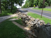
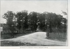
Then and Now: The 1923 Hancock Avenue gateway at Taneytown Road
 The Hancock Avenue entrance gates that were built in 1923 will be
rebuilt .
There were earlier gates of different designs. In 1882, the Gettysburg
Battlefield Memorial Association created an opening in the stone wall on
the west side of Taneytown Road for access to Hancock Avenue. The
first version, in 1889, was a wood and wire gate. A later version, in
1896, included iron fencing (see photo) from the original fence that had surrounded Lafayette Square Park in Washington, D.C. – the same iron
fencing that now forms the boundary between Evergreen Cemetery and the
Soldiers’ National Cemetery. The park’s monument specialists have the
majority of the historic stones need to rebuild the 1923 gateway. The 1896 version of the Hancock Avenue gate at Taneytown Road used pieces of the old Lafayette Square fence from Washington, D.C. which is closely associated with Daniel Sickles.
  Ziegler’s Grove and Ziegler's Ravine
 During Pickett’s Charge, the left flank of General Pettigrew’s division engaged Union forces in Ziegler’s Grove. Because Battery I, 1st U.S. Artillery was located in Ziegler’s Grove it was heavily shelled during the pre-assault bombardment, inflicting numerous casualties on the battery’s infantry support, the 108th New York, and other nearby infantry units. This project will allow us to replant the missing portion of Ziegler’s Grove. We plan to plant approximately 125 trees including Black Cherry, Shagbark Hickory, Black Gum, White Oak, Red Oak, Tulip Poplar and Honey Locust.
Documentation for reestablishing this ravine comes from a number of sources, including a grading plan in the National Park Service files showing the area before the Cyclorama building parking lot was developed. In addition, archaeology helped establish the exact location of a portion of the original Hancock Avenue during testing completed by the park when we replaced a water line extension in 2006.
 Looking toward the National Cemetery along the old commemorative walkway, the photograph shows the dip known as Ziegler's Ravine. Hancock Avenue cuts across the far side of the ravine. The 88th Pennsylvania Marker, in its original location, is on the left. The profile of Ziegler's Ravine will be especially noticeable to those driving on Hancock Avenue as the road will proceed down a dramatic dip and then come back up for an approximately six foot change in elevation. The NPS will also rebuild some stone walls near Hancock Avenue and along commemorative walkway that was surfaced with crushed stone.
This posted has been edited from the Text Source: From The Fields of Gettysburg


No comments:
Post a Comment